


Voting District 0998400000010, Macomb County, Michigan
About
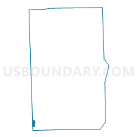
Outline

Summary
| Unique Area Identifier | 597835 |
| Name | Voting District 0998400000010 |
| County | Macomb County |
| State | Michigan |
| Area (square miles) | 0.79 |
| Land Area (square miles) | 0.79 |
| Water Area (square miles) | 0.00 |
| % of Land Area | 100.00 |
| % of Water Area | 0.00 |
| Latitude of the Internal Point | 42.47331170 |
| Longtitude of the Internal Point | -83.07941830 |
Maps

Graphs
Select a template below for downloading or customizing gragh for Voting District 0998400000010, Macomb County, Michigan


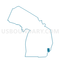
Neighbors
Neighoring Voting District (by Name) Neighboring Voting District on the Map
- Voting District 0998400000008, Macomb County, MI
- Voting District 0998400000011, Macomb County, MI
- Voting District 0998400000013, Macomb County, MI
- Voting District 0998400000068, Macomb County, MI
- Voting District 1253742000005, Oakland County, MI
- Voting District 1253742000006, Oakland County, MI
- Voting District 1255056000003, Oakland County, MI
- Voting District 1255056000004, Oakland County, MI
Top 10 Neighboring County Subdivision (by Population) Neighboring County Subdivision on the Map
- Warren city, Macomb County, MI (134,056)
- Madison Heights city, Oakland County, MI (29,694)
- Hazel Park city, Oakland County, MI (16,422)
Top 10 Neighboring Place (by Population) Neighboring Place on the Map
Top 10 Neighboring Unified School District (by Population) Neighboring Unified School District on the Map
- Warren Consolidated Schools, MI (113,914)
- Hazel Park City School District, MI (20,911)
- Fitzgerald Public Schools, MI (17,207)
- Madison Public Schools, MI (11,927)
Top 10 Neighboring State Legislative District Lower Chamber (by Population) Neighboring State Legislative District Lower Chamber on the Map
- State House District 28, MI (89,381)
- State House District 26, MI (86,932)
- State House District 27, MI (83,872)
Top 10 Neighboring State Legislative District Upper Chamber (by Population) Neighboring State Legislative District Upper Chamber on the Map
- State Senate District 13, MI (259,747)
- State Senate District 14, MI (257,297)
- State Senate District 9, MI (249,029)
Top 10 Neighboring 111th Congressional District (by Population) Neighboring 111th Congressional District on the Map
Top 10 Neighboring Census Tract (by Population) Neighboring Census Tract on the Map
- Census Tract 2636, Macomb County, MI (5,279)
- Census Tract 1751, Oakland County, MI (5,083)
- Census Tract 1816, Oakland County, MI (4,806)
- Census Tract 2635, Macomb County, MI (4,233)
- Census Tract 1752, Oakland County, MI (4,062)
- Census Tract 2623, Macomb County, MI (3,958)
- Census Tract 2624, Macomb County, MI (3,247)
- Census Tract 1750, Oakland County, MI (2,967)